The Cao Bang Loop (3 Days): See The North Before The Crowds Do
Ask any traveler about the ultimate route in Northern Vietnam and they will instantly scream, “The Ha Giang Loop!” But wait. Before you follow the crowd, let me tell you a secret.
Ha Giang’s massive popularity has turned it into a bumper-to-bumper tourist trail. If you are searching for serenity, being stuck behind a convoy of 50 motorbikes is hardly the dream.
This is where the Cao Bang Loop comes in. The true under-the-radar route for 2026.
I’m Oliver, a local expert who has spent over a decade exploring every jungle path and limestone peak in this region. Trust me when I say this: Cao Bang today is exactly what Ha Giang was 10 years ago. Majestic, raw, and blissfully quiet.
Written by Oliver PHUNG (Tour Guide)
Updated on Apr 20, 2026
2 comments
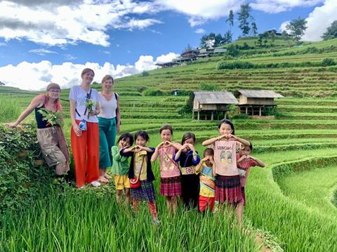
Oliver Phung is a Northern Vietnam-based tour guide and blogger. His favorite topics to write about include cuisine, culture, travel, and under-the-radar experiences. Oliver possesses a deep, detailed understanding of the region, from the indigenous culture of the Hmong in the Northwest to the highland lifestyle of the Tay in the Northeast. Whether he is exploring ancient architecture or geological landscapes, he is always eager to share his insights with his readers.
Beyond his work at Kampá Tour, he produces specialized travel content on platforms such as Reddit, Instagram, LinkedIn, and various other publications.
>>> Author's note: This itinerary focuses on the daily routes and logistics. For a broader look at the region’s weather, ethnic culture, and must-eat dishes, check out my "The not-your-usual guide to Cao Bang" first. It will give you the full context you need for an unforgettable journey.
What is the Cao Bang loop?
Technically, “Cao Bang Loop” isn’t an official name on the map. It’s a term coined by the travel community, inspired by its more famous neighbor, the Ha Giang Loop.
But that’s where the similarity ends.
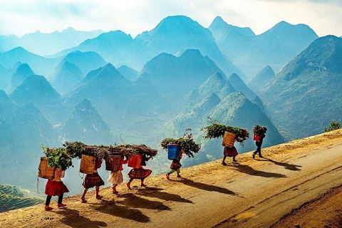
While the Ha Giang Loop (around 380 km) is celebrated for vertical cliffs and adrenaline fueled riding, the Cao Bang Loop is defined by diversity. Stretching over roughly 338 km, the route unfolds through a constantly changing landscape, from powerful border waterfalls and hidden stone villages to wide green valleys and jagged limestone peaks.
A stopover point in the Cao Bang loop
“Do I need 5 days to see it all?” Many guidebooks say yes. But after nearly a decade navigating these mountains, I’ve learned that the smartest route is not the longest one. A well designed 3 day Cao Bang Loop captures all the highlights, skips the dull connector roads, and takes you straight to the magic.
The Cao Bang Loop: A Smarter 3-Day Itinerary
Day 1: The Border Frontier of Cao Bang
📌 Day 1 Tour Logistics
🚗 Distance: 115 km (Relaxed pacing with plenty of photo stops)
⛰️ Route: Cao Bang city - Ma Phuc Pass - Phong Nam - Ngoc Con Valley - Ban Gioc Waterfall - Khuoi Ky
🍲 Meals Included: Lunch, Local Dinner (Featuring famous smoked sausage & regional specialties)
🏡 Accommodation: Authentic Homestay in Khuoi Ky Stone Village (Private room & Western standard bathroom options available)
The first day on the Cao Bang loop was absolutely stunning.
Stop 1: Mã Phục Pass
Leaving the bustle of Cao Bang City behind via National Highway 3, the landscape shifts dramatically. Before you even reach the pass proper, you face the An Lai Slope, a straight, almost vertical ribbon of asphalt that appears to shoot directly into the sky. It is a daunting prelude to the main event.
The straight uphill path of An Lai slope
Rising 700 meters above sea level, Ma Phuc Pass serves as the dramatic gateway to the Global Geopark. Famous for its seven steep, serpentine tiers coiling around limestone pillars, it is often compared to Ha Giang's Tham Ma Pass. Yet, Ma Phuc carries a weight of history that feels far more ancient.
The name “Ma Phuc” (Kneeling Horse) stems from an 11th-century legend where leader Nung Tri Cao’s warhorse collapsed here in sheer exhaustion. To this day, the flanking limestone ranges resemble those weary steeds. While riders must fixate on the hairpin turns, car passengers have the luxury to lean back and trace these legendary shapes etched into the rock.
Ma Phuc Pass is a breathtaking mountain pass in Northeast Vietnam, known for its winding roads and stunning limestone views
Oliver’s Quick Notes:
• Stop at the summit for bánh áp chao and Cao Bang smoked sausage. It is the best mountain fuel you will find.
• This entire landscape was once submerged beneath the ocean 260 million years ago, shaped by ancient submarine volcanic activity.
• Nung Tri Cao is often regarded as the spiritual king of Cao Bang, a borderland figure comparable to Vuong Chi Sinh in Ha Giang.
Stop 2 & 3: Phong Nam and Ngoc Con Valley
The journey continues with a 56km stretch toward the Chinese frontier, a route that feels less like a commute and more like an escape. As you push deeper into the hinterlands, the roadside clutter evaporates. Concrete houses are replaced by limestone corridors, leaving you on a solitary path where the silence is punctuated only by the hum of your engine and the rush of wind against your face.
Phong Nam always gives me a very special feeling whenever I visit
This isolation is the gateway to Phong Nam, a Tay ethnic hamlet that feels entirely untouched by the 21st century. Framed by the emerald currents of the Quay Son River, the village is a sanctuary of stilt houses and rice paddies. There are no multi-story hotels here, no karaoke bars. Instead, life moves at the pace of the harvest: buffaloes graze lazily, children play in the mud, and villagers in traditional indigo-dyed clothing tend to the fields. It is a place to kill the ignition and simply connect with nature.
Life feels like it slows down in Phong Nam
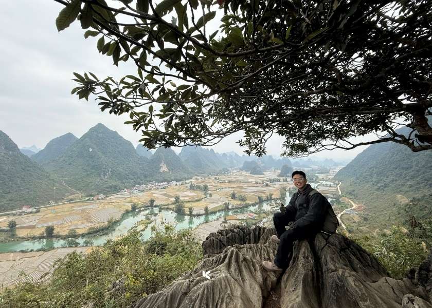
For those willing to explore further, Ngoc Con lies just ten kilometers down the road. While it mirrors Phong Nam’s pastoral beauty, Ngoc Con offers a unique reward: the Phi Pha Viewpoint. Reaching this spot requires a steep 1km hike, but the effort pays off with a spectacular panorama. From the summit, you can gaze out over a sea of limestone peaks that blur the invisible line where Vietnam ends and China begins.
A panoramic view of the two valleys from the Phi Pha Viewpoint
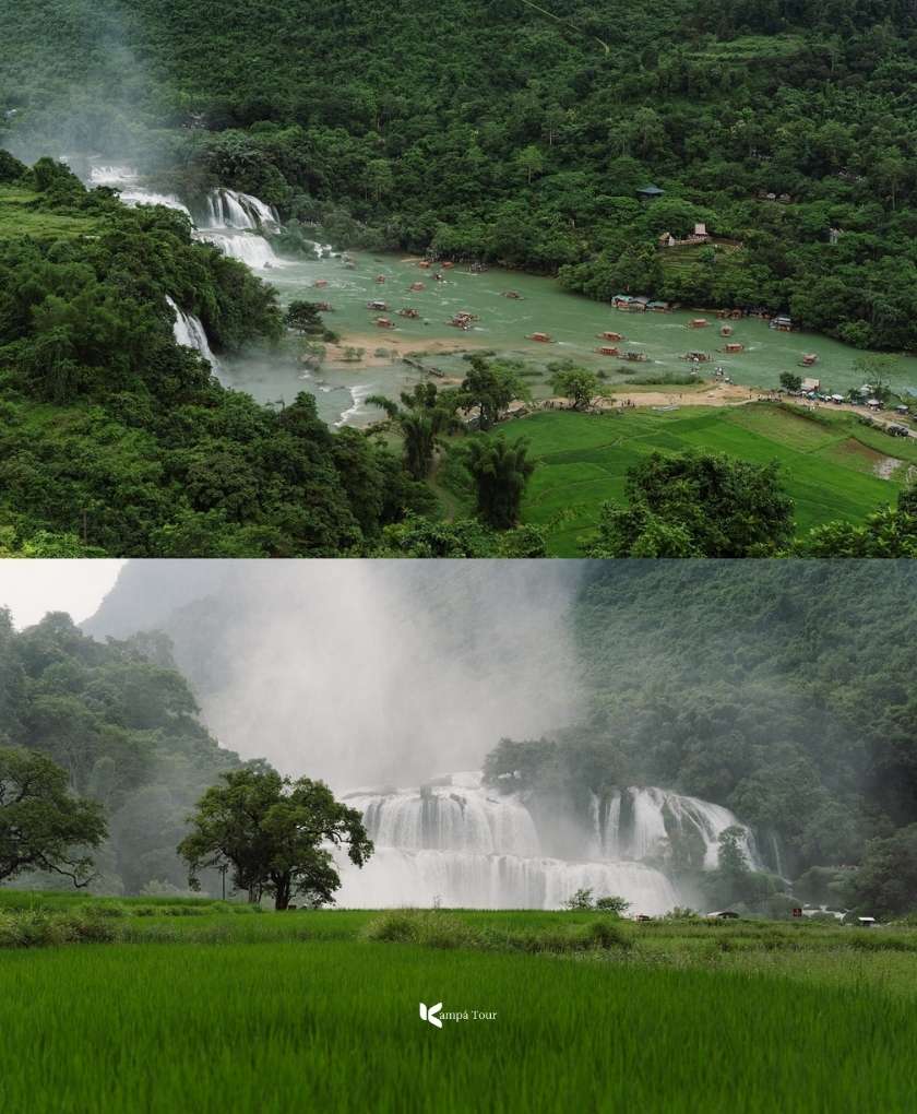
By the time we reach this fifth stop, we have covered nearly 70% of the day’s journey. You might ask, “Why place the most famous landmark near the end?” Think of it as the grand finale, a well deserved reward after traversing over a hundred kilometers of mountain passes.
But there is a tactical reason for this timing. While old guidebooks might tell you to arrive at noon, the local rhythm has shifted. The new “Golden Hour” is 2:00 PM. This is when the upstream hydroelectric dam typically releases its gates, transforming the falls from a gentle flow into a thunderous, turquoise roar. Arriving any earlier means missing this spectacle, while arriving at this time means catching nature at its peak power.
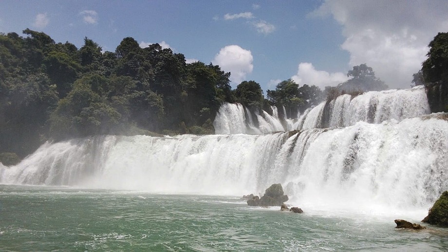
Panoramic view of Ban Gioc Waterfall
Ban Gioc is not just about size, it is undeniably massive and ranks as the largest border waterfall in Southeast Asia. The true magic lies in its atmosphere. The Quay Son River acts as a natural stage dividing Vietnam and China. Here, on a bamboo raft misted by the spray, you will likely find yourself waving to Chinese tourists on their own rafts just meters away. For a fleeting moment, amid the roar of the water and the laughter, the rigid lines on the map seem to dissolve completely.
The small waterfall area is under Vietnamese sovereignty
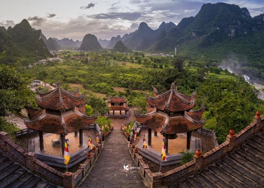
After the rush of the waterfall, a short drive up the mountain offers a necessary shift in perspective. From the grounds of Truc Lam Pagoda, the thunderous Ban Gioc below is reduced to a silent white ribbon, and the river looks less like a political divide and more like a silk thread weaving between two nations.
But this structure is more than just a viewpoint. It is a statement of identity. Built in the tradition of Truc Lam Zen, the only purely Vietnamese Buddhist sect founded by the warrior king Tran Nhan Tong, it embodies the philosophy of “Engaged Buddhism.” Unlike traditions that retreat from the world, Truc Lam connects spiritual practice directly with the destiny of the nation.
Truc Lam Pagoda stands majestically on the hilltop
You will notice a fascinating pattern if you travel Vietnam’s northern frontiers. From Ha Giang to Lang Son, similar pagodas are strategically placed along the borderlines. They serve as spiritual milestones and a form of soft cultural sovereignty. Here, the ringing of the temple bell at twilight rolls across the valley, quietly affirming that while borders are drawn by politics, the land is safeguarded by culture and peace.
When viewed from above, you can see the entire Ban Gioc waterfall
Oliver’s notice:
The "Peace" Strategy: In Asian tradition, pagodas are neutral sanctuaries. Placing one here sends a powerful diplomatic message: this border is guarded by compassion, not just military force.
Bamboo Diplomacy: "Truc Lam" means Bamboo Forest. It is the perfect metaphor for Vietnam: flexible enough to bend in the storm, yet deeply rooted and resilient.
Getting Up: The climb is manageable on foot. However, for a fun experience, you can hire a local motorbike taxi to whisk you up for a small fee (approx. 50,000 VND round trip).
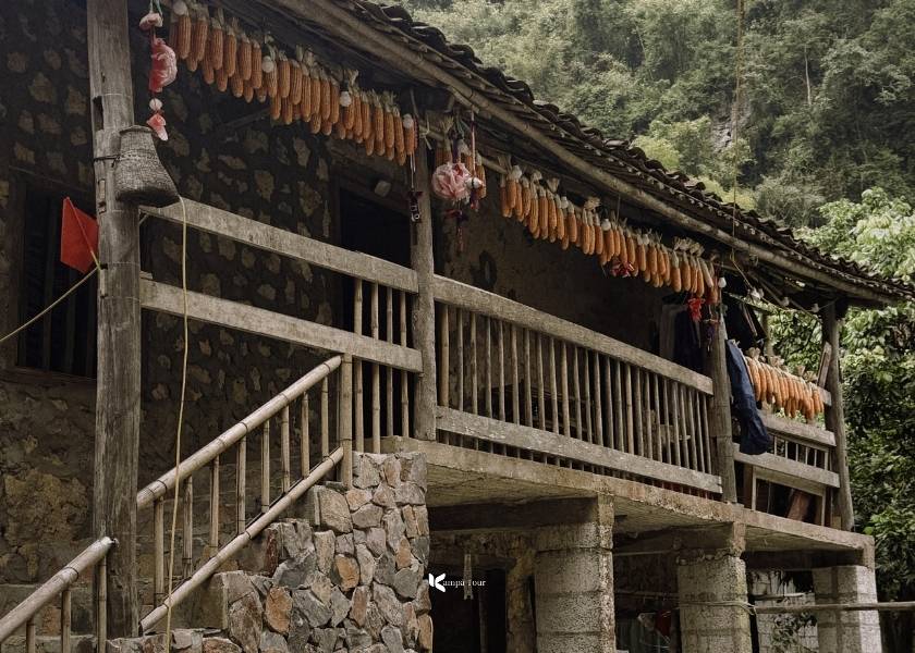
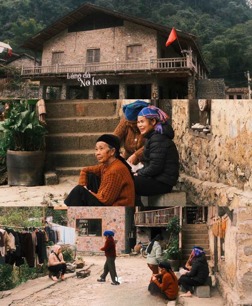
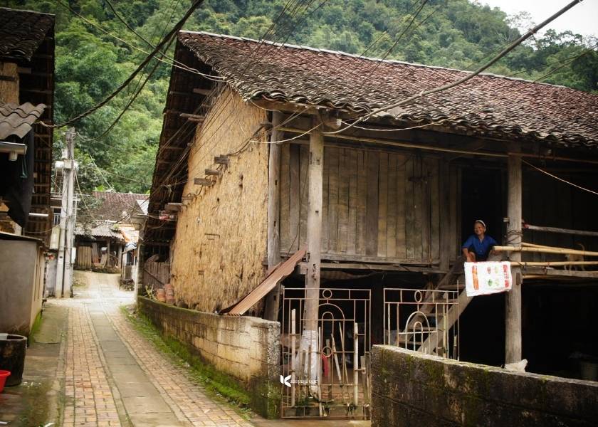
Stop 6: Khuoi Ky village
As twilight settles, we reach our final sanctuary, Khuoi Ky. Unlike typical wooden villages, this one is built entirely from solid limestone. Constructed between 1594 and 1677 as a refuge for the fleeing Mac Dynasty, these stilt houses once served as defensive bastions against bandits. To the local Tay people, stone also carries deep spiritual meaning. They practice Stone Worship and believe stone is the origin of life and the center of the universe.
A traditional Tay house in Khuoi Ky stone village
Tonight, we sleep in history. The village offers authentic homestays beneath traditional yin yang tiled roofs. Imagine sharing smoked pork and corn wine by a warm fire, sheltered by 400 year old stone walls. On Saturdays, you can even join the villagers for a traditional ethnic dance performance, a perfect and grounding end to a high energy day. To understand more about the etiquette of staying with ethnic families, see my guide on Homestay in Vietnam: Live like a local!
Everyday life here
Day 2: The Cultural Maze & the Giant Eye of Cao Bang
📌 Day 2 Tour Logistics
🚗 Distance: 84 km (Scenic countryside roads)
⛰️ Route: Khuoi Ky village - Nguom Ngao cave - Little Ban Gioc - Ban Viet Lake - Quang Uyen (traditional village) - God Eye mountain
🍲 Meals Included: Breakfast, Lunch, Special BBQ Dinner under the stars
🏡 Accommodation: Premium Glamping/Camping at Nam Tra Valley or nearby private Eco-Homestay
The second day of this Cao Bang Loop journey will be more relaxed, as we will experience a blend of stunning landscapes and encounters with local people.
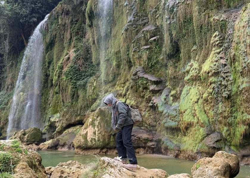
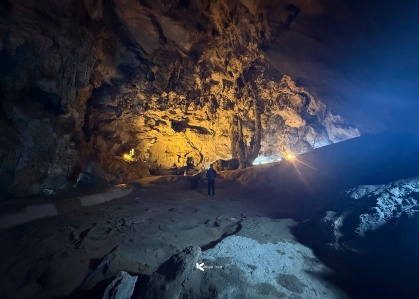
Stop 1: Nguom Ngao Cave, The Tiger’s Den
Just a short walk from our homestay lies Nguom Ngao. I won’t bore you with the geological history (you can read the full backstory in my Cao Bang Guide here). Today, let’s focus on the feeling.
Inside Ngườm Ngao Cave
Stepping inside is an instant relief. The cave maintains a constant temperature of around 18°C to 20°C year-round, acting as a massive natural air conditioner against the humid heat outside. It is dark, damp, and incredibly quiet.
The beauty here comes with a challenge. The limestone floor is perpetually wet and incredibly slippery. Please, do not wear flip-flops or crocs. I have seen too many travelers struggle to keep their balance here. A sturdy pair of sneakers with good grip is non-negotiable.
Oliver’s Adventure Tip: Currently, there are two ways to explore.
The Dry Route: A leisurely walk on wooden paths, perfect for admiring the formations up close. Best for winter.
The Wet Route (Rafting): An adventure option where you wade and raft through the underground river. Highly recommended in summer when the water levels are high and the experience is at its most thrilling.
New route to Ngườm Ngao Cave
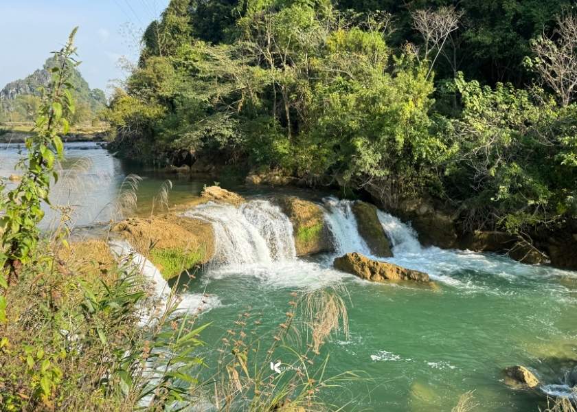
Stop 2: Little Ban Gioc
Driving along the gentle road toward Quang Uyen, we stumble upon Thoong Got, affectionately known as “Little Ban Gioc”.
Think of this spot as nature’s pencil sketch before it painted the masterpiece farther downstream. Located on the middle reaches of the Quay Son River, this landscape is the result of ancient tectonic fractures folding the limestone. It shares the same geological DNA as the famous waterfall, simply expressed on a more intimate scale.
Little Ban Gioc
But the atmosphere here is entirely different. While the main falls roar with power, Little Ban Gioc whispers. There are no rafts and no tickets, just a serene cascade framed by bamboo groves. It is the perfect place to park the bike, wander into the village, and observe local life in its most honest and unfiltered form.
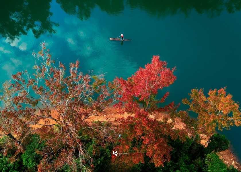
Stop 3: Ban Viet Lake
This is a destination you likely will not find in any standard tour brochure. Most operators skip it, and for good reason. The access roads are narrow, winding, and completely devoid of tourist amenities. But that isolation is precisely why I insist on taking you here.
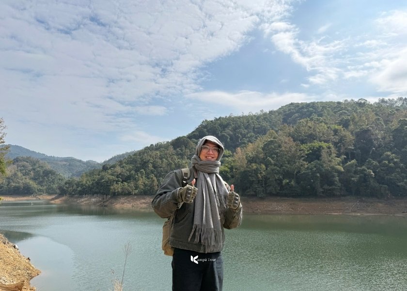
Ho Ban Viet Lake was photographed by drone
Though technically an artificial hydroelectric reservoir, Ban Viet feels entirely wild. It transforms with the seasons, becoming a cooling emerald expanse perfect for swimming and rafting in the summer, or a rare spectacle of flaming red maple leaves in the winter. It is a place to pause, close your eyes, and soak in a tranquility that belies its man-made origins. Unpacking a picnic here is the perfect choice. Just remember to pack out your trash to keep this hidden gem pristine.
And this is what we see from the front of the lake
Stop 4: The Artisan Valley (Quang Uyen)
Crossing into Quang Uyen District, the cultural backdrop changes completely. We are now in the heartland of the Nung An people. This area feels less like a standard stopover and more like a living museum of craftsmanship. While modernization has wiped out traditional trades elsewhere, here, the rhythm of life is still dictated by the ancient arts of metal, scent, and paper.
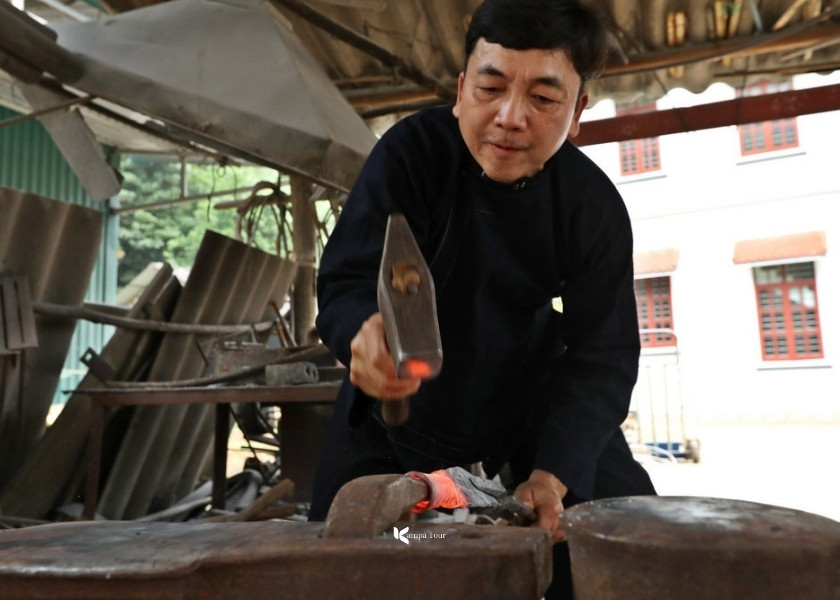
1. Phuc Sen Blacksmith Village, The Sound of Steel
You will likely hear Phuc Sen before you see it. As you approach, the peaceful valley air is broken by a rhythmic cacophony, the clang of heavy hammers striking anvils and the sharp hiss of red hot steel plunged into water.
This is the largest and oldest blacksmith village in the region. What makes Phuc Sen extraordinary is its refusal to modernize. Unlike knife villages near Hanoi that rely on industrial stamping machines, the Nung An artisans here remain proudly traditional. Every blade is forged from recycled leaf springs taken from old trucks, shaped entirely by fire, sweat, and muscle.
Take a stroll around the blacksmith village
I tried my hand at the anvil, and trust me, it is a brutal dance. Swinging that hammer demands serious endurance and earns instant respect. The work is exhausting, but holding a finished knife, forged through your own effort under a master’s guidance, is a reward far greater than any souvenir you could buy in a shop.
Blacksmiths in Phuc Sen village
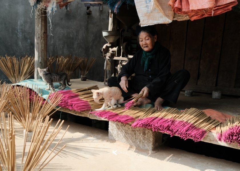
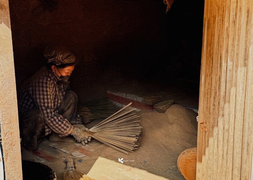
2. Phia Thap Incense Village, the Scent of Tradition
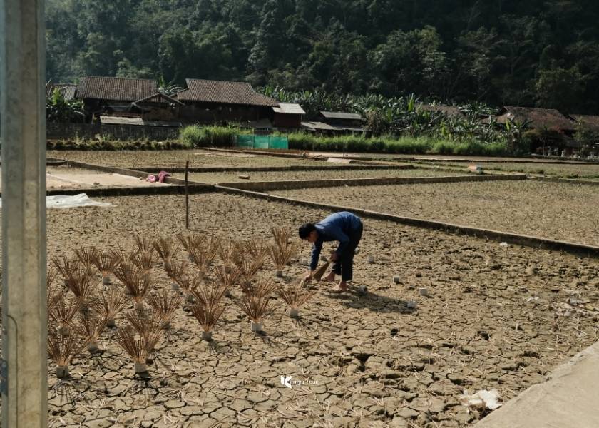
If Phuc Sen is an assault on the ears, Phia Thap is a soothing sanctuary for the nose. Just a few kilometers away, the clang of metal is replaced by a meditative silence, broken only by the soft rustle of bamboo and the pervasive woody fragrance of natural incense.
The old woman is drying her finished incense sticks for the last time
This village is the spiritual supply line for the entire province. Over 50 Nung An households work here, and it is truly a community effort. From elders with weathered hands to children fresh out of school, everyone plays a part. The process is mesmerizing to watch. Bamboo sticks are dipped into a glutinous mixture of wild leaves and sawdust, then rolled with hypnotic precision.
When not cultivating rice, people use the rice paddies to dry incense sticks
While the village is incredibly photogenic, especially when bundles of incense are fanned out to dry in the fields like blooming maroon flowers, there is a gritty reality behind the beauty. Standing there for just twenty minutes, I could feel fine sawdust coating my skin and lungs. It gave me a profound appreciation for the villagers who work in this haze from dawn until dusk to keep the tradition alive.
Wood sawdust mixing process
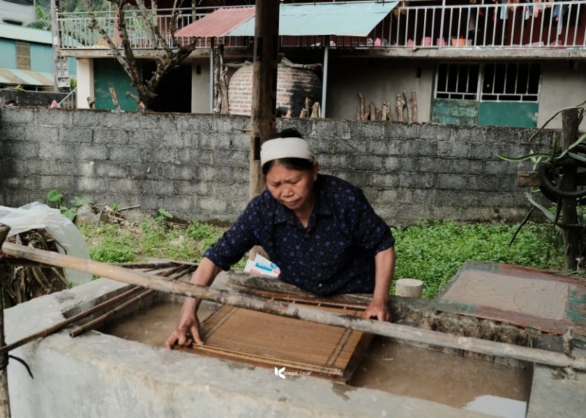
3. Dia Tren Paper Village – The Fading Art
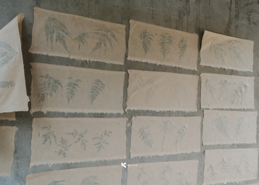
Unlike its neighbors, Dia Tren is hidden. With no signs to guide you, finding it requires venturing 2 km off road and effectively leaving the modern world behind. It is a sobering reality. Only three households here still practice the ancient craft of making paper from tree bark.
The road to Dìa Trên paper-making village
Inside the matriarch’s house, time seems to stop. I watched as she transformed wood pulp into delicate sheets using bamboo molds, a slow and rhythmic process untouched by machines. The hospitality is just as raw and warm. The family even treated me to hot sweet potatoes fresh from the fire.
The elderly artisan is showing me how to make a sheet of paper
After that, the finished paper, pressed with wild forest leaves, carries a faint and pleasant fragrance. I highly recommend buying a handmade notebook here. It is more than a souvenir. It is a direct contribution to keeping this fragile heritage alive.
My finished product isn't too bad, is it?? :)
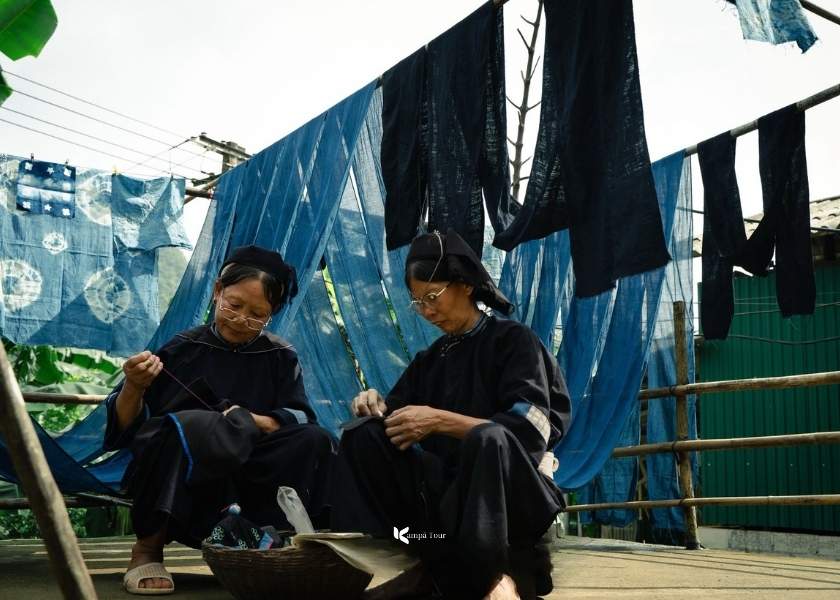
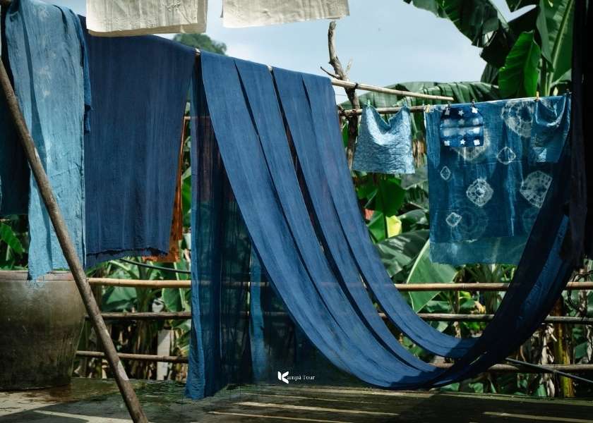
4. Khao Village – The Indigo Soul
Our final stop completes the portrait of the Nung An people. If Phuc Sen provides the tools and Phia Thap the spiritual scent, Khao Village provides the identity: the signature Indigo Blue clothing you see worn throughout these mountains.
The Nung An woman is embroidering indigo fabric
This isn’t a look-but-don’t-touch museum. We roll up our sleeves and join the villagers at the dyeing vats and weaving looms. Watching the fabric magically change color as it oxidizes in the air is mesmerizing. You might leave with slightly blue-stained fingers, but you’ll also leave with a profound respect for every thread woven into the local culture.
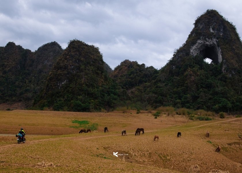
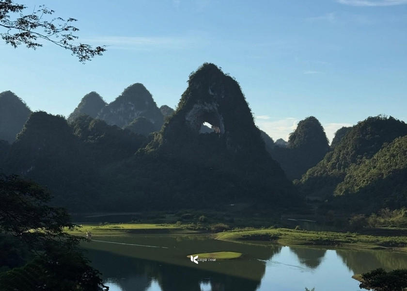
Stop 5: God’s Eye Mountain (Nui Mat Than) – The Nomadic Valley
Leaving the intricate craft villages behind, we end our day surrounded by pure and unfiltered nature. Our destination is Nam Tra Valley, home to one of the most surreal geological spectacles in Vietnam, Nui Mat Than, also known as God’s Eye Mountain.
The name explains itself. Piercing through the center of a massive limestone tower is a perfect circular hole, roughly 50 meters in diameter, resembling a giant cyclopean eye gazing down at the valley floor. Locals call it “Phia Piot”, meaning the Mountain with a Hole, and watching the sunset shine directly through this opening is a deeply spiritual experience.
The Eye of God Mountain during the dry season
But the mountain is only half the story. The valley below feels completely detached from the rest of Vietnam. With rolling green pastures, free roaming horses, and wandering buffaloes, the landscape looks more like the Mongolian steppes than Southeast Asia.
Well, to conclude the day, you could drive another 27 km back to the familiar comforts of Cao Bang City. However, I chose a more memorable option by camping overnight right here in the valley. There is no need to worry about logistics. Local families now offer full tent rentals and home cooked meals, allowing you to enjoy a relaxed barbecue under the stars with complete peace of mind.
The Eye of God Mountain during the rainy season
Day 3: Revolutionary History & Tribal Heritage
📌 Day 3 Tour Logistics
🚗 Distance: 100 - 146 km (Depending on your chosen route)
⛰️ Option 1 (The Full Experience): God’s Eye Mtn → Pac Bo → Khau Coc Cha Pass. This option allows you to continue onward to Ha Giang, or return to Hanoi by overnight sleeper bus. (146km)
⛰️ Option 2 (The Relaxed Route): God’s Eye Mtn → Pac Bo → Return to the city for a coffee & massage. (100km)
🍲 Meals Included: Breakfast, Farewell Lunch
📍 Drop-off: Cao Bang City (Afternoon) or Direct transfer back to Hanoi via Limousine Van.
Today is the biggest driving day. Depending on your energy levels, you can choose to conquer the majestic pass or soak in revolutionary history. As for me, I chose to add option 2 because that's what makes the trip complete. But if you have less time, option 1 is still very worthwhile.
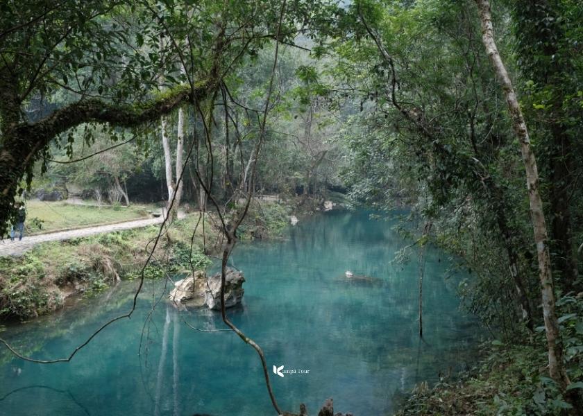
Stop 1: Pác Bó Cave
Pác Bó strikes a rare equilibrium between profound history and sublime nature. Even without its political significance, the scenery alone is worth the drive. A limestone amphitheater hidden deep in the jungle creates a setting that feels both intimate and awe inspiring.
The turquoise water at Lenin Stream, Pac Bo
The walking trail here is spectacular. On one side, the Lenin Stream glows with an almost iridescent turquoise hue. On the other, a dense forest canopy vibrates with the constant hum of cicadas. The path eventually leads to Cốc Bó Cave, where Hồ Chí Minh lived in secrecy in 1941. Stepping inside, the heavy jungle heat disappears, replaced by cool, damp air that softly illuminates his humble wooden bed and the famous limestone “table” where he worked.
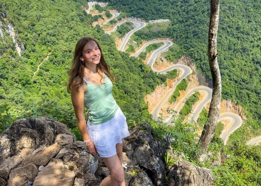
Stop 2: Khau Coc Cha Pass – The Vertical Staircase
Driving west toward Bao Lac, the terrain shifts dramatically. Here, we encounter a geological marvel that seems to defy engineering logic: Khau Coc Cha Pass.
Though only 2.5 km long, the road climbs up a sheer cliff face through 14 brutal hairpin turns. From a distance, it forms a 15-tier structure that looks less like a highway and more like a giant staircase carved into the limestone.
A candid photo of a female tourist at Khau Coc Cha Pass
To truly grasp the scale of this “concrete python”, you must hike about 30 minutes to the summit viewpoint. Standing there and looking down at the road coiling tightly below is one of the most surreal, drone-like perspectives you can witness with your own eyes in Vietnam.
Stop 3: Bao Lac – The Tribal Frontier
Just beyond the pass lies the remote district of Bao Lac. This region feels completely detached from the modern world and serves as a sanctuary for some of Vietnam’s most distinct ethnic groups.
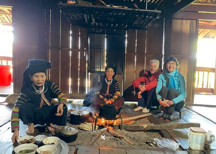
Khuoi Khon (The Black Lolo): High in the mountains, this village is home to the Black Lolo people. Unlike the colorful attire of their neighbors, the Lolo wear distinctive black clothing adorned with intricate and vibrant geometric appliqués. Their isolation has acted as a preservative, keeping their unique dialect and wooden stilt architecture almost entirely intact.
My guests had a friendly meal at Khuoi Khon Cultural Village
The Tribal Market: If your visit aligns with a market day, the quiet town suddenly bursts into color. This is not just a place to trade buffaloes or vegetables. It is the social heartbeat of the region. You will see a mesmerizing mix of Dao, Mong, and Lolo villagers descending from the hills to trade goods, share stories, and drink corn wine together.
The market in Bao Lac is always the most vibrant place
In three days, we have touched the Chinese border, walked in the footsteps of revolutionaries, and shared tea with isolated tribes. This route is not just a drive; it is a deep dive into a raw, unfiltered Vietnam that few travelers ever see about Cao Bang loop.
Want to experience this exact journey? Do it the safe way!
Over the years of exploring these mountains, I’ve seen countless travelers arrive at Ban Gioc Waterfall completely exhausted from riding motorbikes through heavy rain or navigating the dangerous hairpin turns alongside massive container trucks. The CaoBang loop is breathtaking, but it shouldn't be a survival test.
At Kampá Tour, we believe you should spend 100% of your energy enjoying the scenery, not worrying about potholes, Google Maps, or border police checks. That is why we designed our Private Car & Limousine Tours. You get all the raw, off-the-beaten-path magic of my diary above, but with the safety, comfort, and deep cultural insights that only a local driver and guide can provide.
Perfect for families, couples, and those who want a "Comfort Adventure". Here is how we make it happen for you:
Skip the hassle of planning and let our local experts guide you safely through the Northeast frontier. Whether you are planning a weekend itinerary from Hanoi for your family or a photography expedition, our private guided tour ensures you experience the absolute best of Cao Bang without worrying about logistics, border permits, or mountain road navigation.
✅ What’s Included
🚘 Private Transport: AC car or Limousine van from Hanoi/Cao Bang.
👨🏫 Local Guide: Fluent English-speaking local expert.
🏡 Accommodation: 2 Nights in authentic homestays or eco-lodges.
🍲 Meals: All daily meals (Breakfast, Lunch, Dinner).
🎟️ Tickets & Papers: All entrance fees, Ban Gioc raft & border permits.
Guided Tour vs Self-Riding the Cao Bang Loop: Which is Better?
Many bloggers admit that riding a motorbike through the Loop can be "unnerving" and "exhausting." Here is an honest comparison to help you choose the right style for your trip.
🏍️ Self-Riding (Motorbike)
Your Main Focus: The road. You spend around 80% of your energy watching for potholes, trucks, and buffaloes.
Weather Reality: Full exposure. You feel the rain, mud, and cold directly. It is physically demanding.
Safety Level: Higher risk. Narrow mountain passes, heavy trucks, and fatigue after 4-5 hours of riding increase danger.
Perfect For: Adrenaline junkies and solo riders who want to physically conquer the terrain.
🚙 Guided Tour (Private Car)
Your Main Focus: The view. You are 100% free to look outside, spot hidden details, and take photos without stopping.
Weather Reality: Climate controlled. Rain or shine, you stay dry and comfortable, arriving fresh and ready to explore.
Safety Level: High safety. A professional local driver handles hairpin turns. The safest option for a family itinerary or those traveling with kids.
Perfect For: Photographers, couples, and travelers who want to understand the land rather than just ride through it.
💡 My honest verdict:
Choose the Motorbike if you view the journey as a battle to be won, and you don't mind arriving at the homestay covered in mud and glory.
Choose the Private Car if you view the journey as a documentary. If you want to maximize your sightseeing time, learn deeply about the culture, and end the day feeling relaxed rather than exhausted, the car is the smartest investment.
You can read more to better understand these two options.
1. Is the Cao Bang Loop suitable for beginner riders?
The honest answer is no. Unlike the tourist-friendly Hai Van Pass, this route, specifically Highway QL3, and QL4A, is a vital logistics artery. You will share narrow mountain curves with heavy container trucks and buses on blind corners. If you are not confident on a manual bike, do not take the risk. Opt for a private tour or an Easy Rider service to stay safe.
2. What are the absolute essentials to pack?
It depends entirely on your mode of transport:
For motorbikers: Safety is paramount. A full face helmet, knee and elbow pads, and a high quality raincoat are non negotiable.
For car travelers: Your list is simpler. Bring sturdy walking shoes for slippery caves, a telephoto lens for waterfalls, and a light windbreaker for the evening chill.
3. Where is the best accommodation on the loop?
You have two distinct styles to choose from. For cultural immersion, stay in a traditional stone stilt house in Khuoi Ky Village. It feels like sleeping inside a 400 year old fortress. For modern comfort, choose a resort near Ban Gioc Waterfall to wake up to the sound of rushing water.
>>> Note: On Kampá Tour trips, we pre book selected hidden gem homestays that strike the perfect balance between authentic atmosphere and private, clean facilities.
4. Do I need a Border Permit or need to worry about police checks?
Yes. Since the loop touches the sensitive Chinese border (Ban Gioc, Pac Bo, Ngoc Con), a Border Permit is mandatory for foreigners. Police checks are frequent here.
Puppy time!!
Conclusion
Some say the Cao Bang loop is just an alternative to the Ha Giang loop. I say it is an upgrade. If Ha Giang is the adrenaline, Cao Bang is the therapy. It trades the bumper-to-bumper traffic and rocky plateaus for a world of emerald waters, golden valleys, and genuine encounters with locals who still smile at strangers. It is not about conquering the road. It is about connecting with it.
Don't just tick it off your bucket list. Experience it the right way. Ready for your Comfort Adventure? Contact Kampá Tour today and let us craft your exclusive journey into the heart of the North.
I love this 3-day loop idea, but I’m still a bit confused about the best starting point. If I’m coming from Hanoi, is it better to take an overnight sleeper bus, a limousine van, or arrange a private transfer, and where exactly do people usually get dropped off in Cao Bang City?
0Reply
Oliver Phung23 Feb 2026
If you're coming from Hanoi, you have three options:
Sleeper bus (budget choice)
Departs around 8–9 PM, arrives 4–5 AM. Cheapest option. Drop-off is usually at Cao Bang Bus Station or along Kim Dong Street in the city center. Sleep quality varies.
Limousine van (best balance)
6–7 hours, daytime departure. Much more comfortable than the bus. Most companies offer hotel pickup in Hanoi and drop you directly at your hotel in Cao Bang City center, which is very convenient.
Private transfer (most comfortable)
6–7 hours door to door. Flexible departure time, spacious, zero hassle. Best if you want to arrive fresh and start the loop smoothly.
💡 My honest advice:
If you want comfort without overspending → Limousine van.
If you want maximum ease and flexibility → Private transfer.
Most travelers start the loop from Cao Bang City center near Kim Dong Walking Street.
Planning your trip?
Save time and get expert advice for FREE!
✅ 15 years of local experience
✅ Save up to 40 hours of planning
✅ Travel stress-free from start to finish
Book your free consultation today!


 Our team
 Our team
 Our team
 Our team


.jpg)


If you're coming from Hanoi, you have three options:
Sleeper bus (budget choice)
Departs around 8–9 PM, arrives 4–5 AM. Cheapest option. Drop-off is usually at Cao Bang Bus Station or along Kim Dong Street in the city center. Sleep quality varies.
Limousine van (best balance)
6–7 hours, daytime departure. Much more comfortable than the bus. Most companies offer hotel pickup in Hanoi and drop you directly at your hotel in Cao Bang City center, which is very convenient.
Private transfer (most comfortable)
6–7 hours door to door. Flexible departure time, spacious, zero hassle. Best if you want to arrive fresh and start the loop smoothly.
💡 My honest advice:
Most travelers start the loop from Cao Bang City center near Kim Dong Walking Street.