Vietnam boasts a rich and varied culture, a long and rich history, and breathtaking natural beauty. Are you making travel plans? A Vietnam tourist map is your ticket to unlocking it all. This thorough reference to Vietnam's regions helps you navigate from north to south by breaking down the country's several areas. Do you have visions of the Old Quarter in Hanoi? The streets of Hoi An, lighted with lanterns? The floating markets of the Mekong Delta?
As a travel guide, I can help you make sense of Vietnam from the very beginning. With its rich culture, long history, and diverse landscapes, planning a trip here can feel overwhelming but that’s where a Vietnam tourist map becomes useful.
Written by Nhu PHAM (local expert)
Updated on Jun 15, 2026
6 comments
Nhu PHAM is a Saigon native with a passion for travel, adventure, the French and English language, and making discoveries as a digital nomad. She has already explored many Southeast Asian countries, including Cambodia, Laos, and Thailand. Originally from the South, she has a particular expertise in the South and the Mekong Delta. Currently based in Hanoi, she works for Kampá Tour and is the author of many highly appreciated articles on this blog. If you have any questions or comments, please feel free to share them at the bottom of her articles so that she can answer you directly.
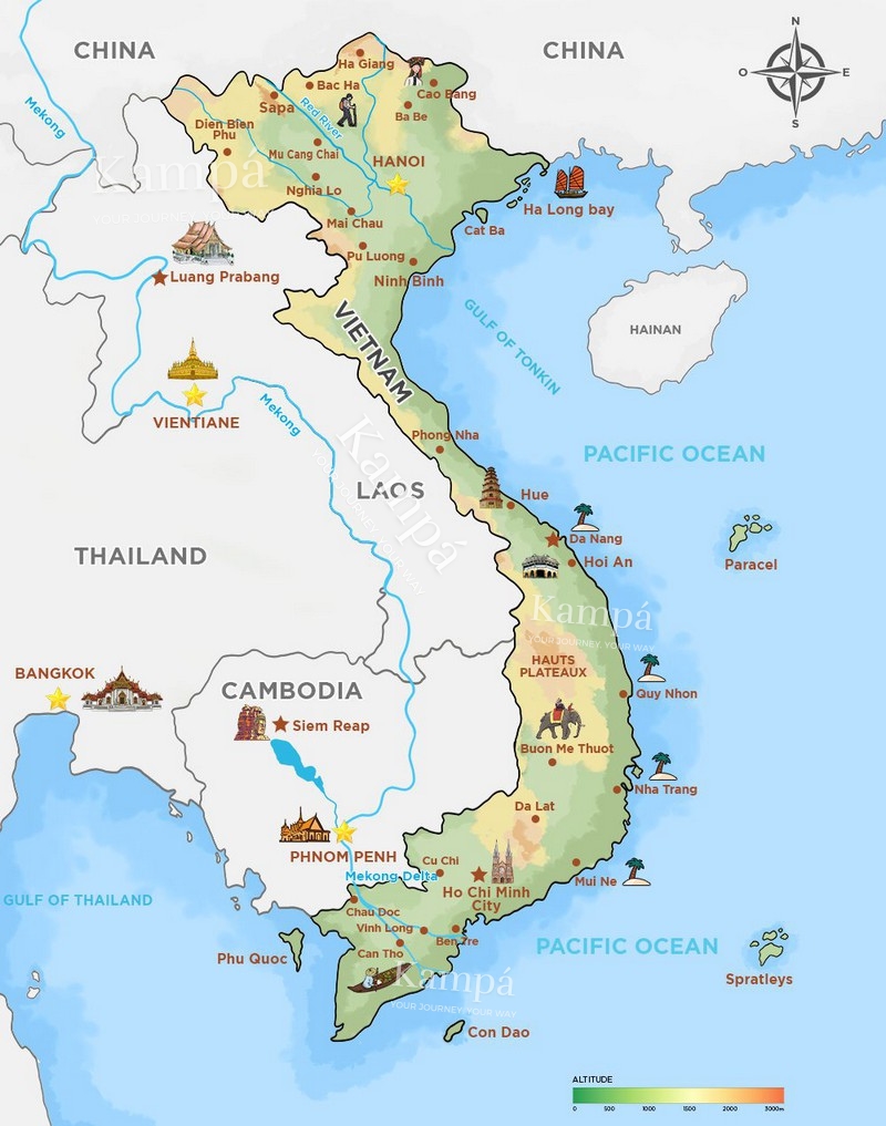
A Vietnam tourist map is the first tool any traveller needs. Vietnam stretches over 1,650 km from north to south, roughly the length of Western Europe, and its three main regions each offer completely different landscapes, climates, and experiences.
This guide combines an interactive Vietnam travel map with regional breakdowns, city-by-city distances, and a practical 14-day itinerary so you can plan your trip from north to south with confidence.
Must-visit destinations: Hanoi, Ha Long Bay, Sapa, Ha Giang, Cao Bang, Ninh Binh, Hue, Hoi An, Da Nang, Ho Chi Minh City, Mekong Delta, Phu Quoc.
How long: 14–21 days for a full Vietnam itinerary
Best way to travel: Domestic flights for long distances + trains and buses for regional routes
Best time to visit: September–November and February–May
1. Vietnam's Geography: Shape, Size & Borders
Located in Southeast Asia, Vietnam is a narrow, S-shaped country covering about 331,000 km². It stretches roughly 1,650 km from north to south and is often compared to a dragon or the letter “S”.
The country varies greatly in width: up to 600 km in the north, but only about 50 km at its narrowest point in Central Vietnam near Phong Nha.
Vietnam shares borders with China (north), Laos (west), and Cambodia (southwest). It is also bordered by the East Sea (South China Sea) to the east, with the Gulf of Tonkin in the north and the Gulf of Thailand in the south.
General information:
Full Country Name: Socialist Republic of Vietnam
Capital: Hanoi
Currency: Vietnam Dong (VND)
Time Zone: GMT+7 (e.g., Vietnam 2 p.m. = USA 2 a.m. Eastern Time)
Since Vietnam shares its border with Laos to the west and Cambodia to the southwest, you'll easily have the opportunity to extend your journey to these two countries. From northern Vietnam, you can travel overland to Luang Prabang, the former capital of Laos.
Additionally, from the southern Mekong Delta, you can journey upstream along the Mekong River to Phnom Penh, the Cambodian capital, and then continue your trip to Siem Reap, either by land or air.
👉 Open our interactive tourist map to explore Vietnam:
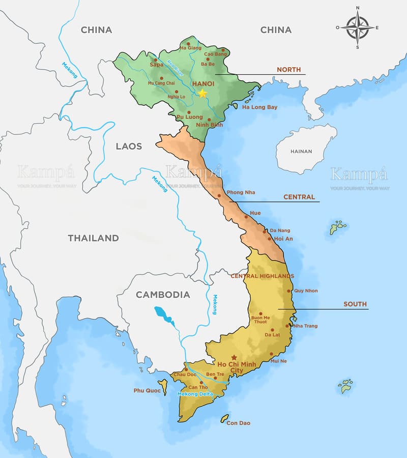
3. Vietnam Tourist Map: 3 Regions Explained
Vietnam is divided into three main regions: the North (the largest portion at the top of the S-shape), the Central region (the longest and narrowest section in the middle), and the South (the lower part of the country).
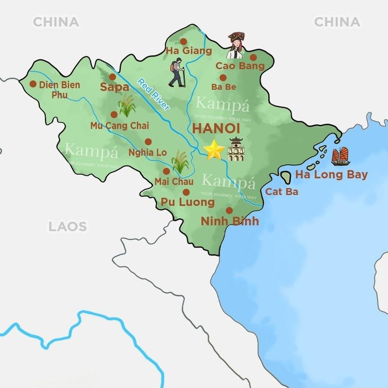
3.1 Northern Vietnam Map: Mountains, Bays & River Delta
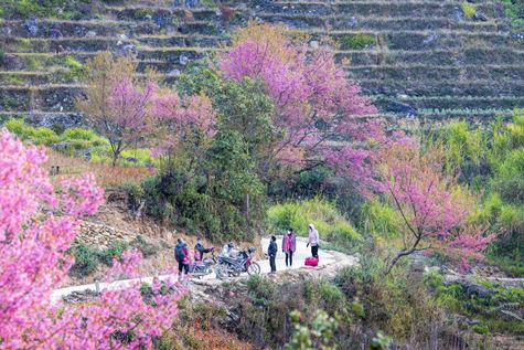
The northern region of Vietnam is dominated by the northern mountains and the Red River Delta, which form the "head" of the country. The northern mountains extend across two sub-regions, first the northwest (the western wing of the north), including places like Nghia Lo, Mai Chau, Mu Cang Chai, and Sapa. This part of Vietnam is renowned for its breathtaking terraced rice fields that seem to stretch endlessly.
Terraced rice fields in the northern mountains of Vietnam.
It is also home to Mount Fansipan and the historic battlefield of Dien Bien Phu. These lands are adjacent to Laos, making it very convenient to visit by crossing the border posts of Tay Trang to Dien Bien Phu or Na Meo. These are off-the-beaten-path routes that allow travelers to appreciate extraordinary landscapes and cultures in every sense of the word.
Here’s the tourist map of northern Vietnam to help you plan your journey through these captivating landscapes and cultural treasures:
The northeastern region, the eastern wing of northern Vietnam, is equally magnificent, boasting breathtaking and wild landscapes. You can admire these landscapes in places like Ha Giang or experience Ha Giang Loop and the Dong Van Geopark, or at the Ban Gioc Waterfalls of Cao Bang and Ba Be National Park, for example. The inhabitants of this region also have fascinating lifestyles and customs to explore.
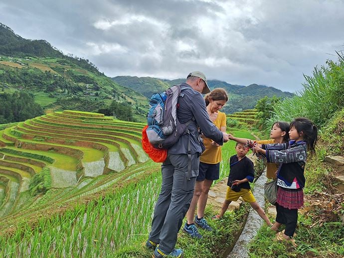
Meeting ethnic children on the trek in northern Vietnam (our travelers)
This vast, northern, mountainous region, consisting of both east and west parts, is indeed the homeland of various ethnic minority groups such as the H'Mong, Dao, Tay, Giay, and Lolo tribes. It is a great destination for hiking enthusiasts, with natural attractions and villages that are less frequented by mass tourism.
These areas offer wonderful opportunities for friendly encounters with the local population. Learn more about the ethnicities of Vietnam.
The ethnic groups of Vietnam.
Hanoi is the starting point for all northern excursions, traversing the Red River Delta. From the political and cultural capital, it's also easy to access Tam Coc (Ninh Binh), an area known for its limestone formations, karst landscapes, and breathtaking flooded rice fields.
While many travelers immediately think of Sapa or Mu Cang Chai for rice terraces and mountains, you might also overlook Pu Luong. This place, on the other hand, offers the same majestic scenery but with fewer tourists, that's why it's quieter and offers a more authentic alternative.
Not to mention the marvelous Halong Bay itself, with a similar topography but on water, featuring hundreds of islands and islets. It remains a "must-visit" for all travelers looking to explore Vietnam.
🌄 Explore Sapa, Ha Giang, Ha Long & more – Start your journey now!
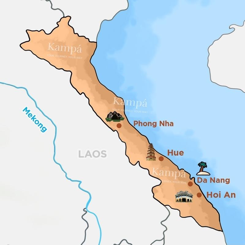
3.2 Central Vietnam Map: UNESCO Heritage & Ancient Cities
The Central region, nestled between the Pacific Ocean to the east and Laos to the west, is renowned for its abundance of natural and cultural sites, some of which are classified as UNESCO World Heritage.
The map of Central Vietnam and its tourist attractions. (Download here)
This narrow part of Vietnam is home to the Phong Nha Ke Bang National Park, featuring the splendid Phong Nha caves, particularly the gigantic Son Doong Cave.
Son Doong, the largest cave in the world
On the other hand, the ancient imperial city of Hue stands as a living testament to the history of the Nguyen dynasty. The city offers a quiet traditional atmosphere, with palaces and royal tombs... By visiting this place, you will be impressed by the feeling of going back in time several centuries.
Thẻ tour 4822, 9916, 4851
Hue Festival 2024
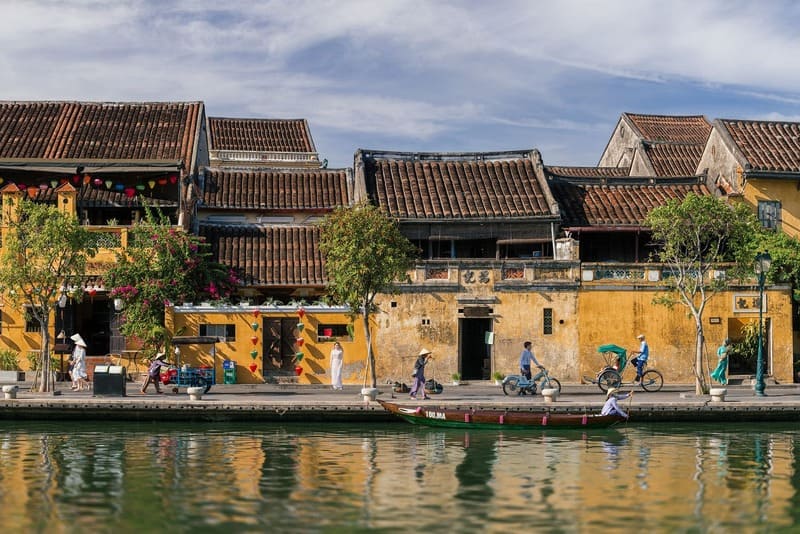
Further south, the ancient town of Hoi An is considered the most charming city in the country, famous for its lantern-adorned streets. From the 15th to the 19th centuries, Hoi An was a bustling port that drew traders from all over the world because of its well-preserved historic houses and charming lanes. Because of this, it has a distinctive architecture today that combines Chinese, Japanese, Vietnamese, and so on.
Hoi An is among the top seven destinations in 2026
according to Travel Off Path, a renowned American travel site.
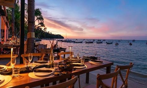
The region's first metropolis, Da Nang, is also worth a visit due to its vibrancy and long stretches of white sandy beaches, as paradisiacal as many others in the Central region. That's why we believe it should be included on your Vietnam tourist map.
The beaches of Central Vietnam are among the most beautiful in the country
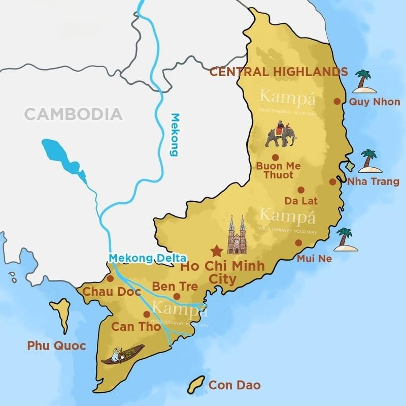
Bordered by Cambodia and the Gulf of Thailand to the southeast,the Southern Vietnam is divided into three sub-regions: the highlands, the Mekong Delta, and the coastal area. The highlands, thanks to their altitude, enjoy a temperate climate in tropical latitudes.
The city of Da Lat (or Dalat), its capital, is a legacy of the colonial era, which has made it a resort town favored by Europeans. The Southern Highlands have become tourist attractions with renowned features such as elephants and plantations of coffee, tea, and rubber trees.
The map of Southern Vietnam and its tourist sites. (Download here)
The southern coastal region of Vietnam stretches from the city of Hoi An to Vung Tau, north of the Mekong Delta. It boasts beautiful beaches, especially in the coastal cities of Quy Nhon, Nha Trang, Mui Ne, and their surroundings.
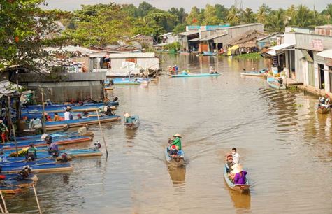
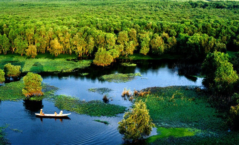
The third sub-region in the South is the Mekong Delta, a unique world that combines both land and water. It is a fertile area thanks to the alluvial deposits from the tributaries and branches of the mighty Mekong River.
The Mekong River originates thousands of kilometers away from Vietnam, in the Himalayas and Tibet, traversing several Southeast Asian countries before dividing into two major branches and flowing into the sea near Ho Chi Minh City.
The beauty of the Mekong Delta.
The lives of the delta's population are deeply influenced by this watery environment, especially along the canals. A prime example of this is the floating markets, which involve unusual means of transportation and commercial activities.
One of the best ways to discover the sub-region's distinct appeal is to visit these markets.
Tra Su Cajuput Forest
In short, you can take a fast boat up the Mekong River and reach Cambodia in just a few hours, which is a popular "two-in-one" trip. Why not explore our Vietnam-Cambodia tour suggestions?
>>> Explore the country from north to south now:
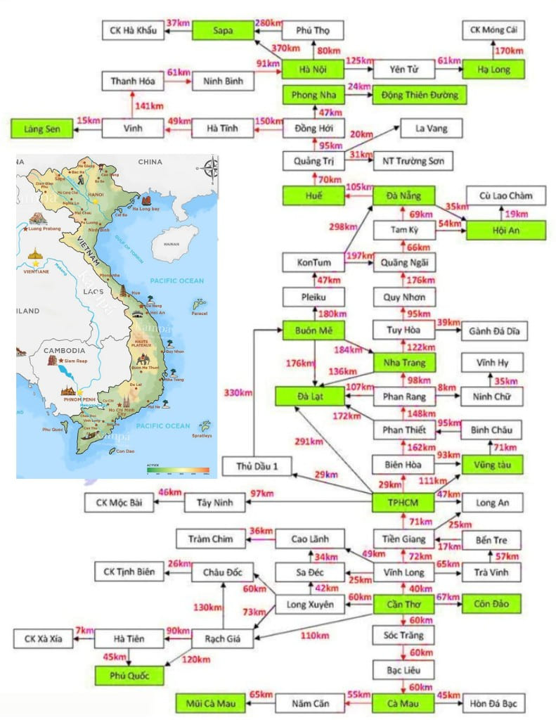
4. How Far Is It Between Vietnam's Major Cities?
Route
Distance (approx.)
By car / private transfer
By train
By flight
Hanoi → Ninh Binh (Tam Coc/Trang An)
90–100 km
1.5–2 hours
2–2.5 hours
N/A
Hanoi → Ha Long Bay
140–160 km
2–3 hours (expressway)
N/A
N/A
Hanoi → Sapa (Sapa town)
310–320 km
5–7 hours
Overnight train to Lao Cai ~8 hours + transfer to Sapa ~1–1.5 hours (total ~9–9.5 hours)
N/A
Hanoi → Hue
~670 km
12–13 hours (long-haul)
12–14 hours (often overnight)
1–1.25 hours
Hanoi → Da Nang
~760–770 km
14–16 hours (long-haul)
16–18 hours (often overnight)
1.25–1.5 hours
Hue → Hoi An
120–140 km
2.75–3.5 hours
Hue → Da Nang ~2.5–3 hours + transfer ~1–1.5 hours (total ~3.5–4.5 hours)
N/A
Ho Chi Minh City → Can Tho (Mekong gateway)
150–170 km
3–4 hours
N/A
N/A
Ho Chi Minh City → Da Lat
275–310 km
6–8 hours
N/A
0.75–1.0 hours
Ho Chi Minh City → Phu Quoc
(air route)
8–10 hours (road + ferry, varies by route)
N/A
0.75–1.0 hours
5. Vietnam City Maps: Hanoi & Ho Chi Minh City
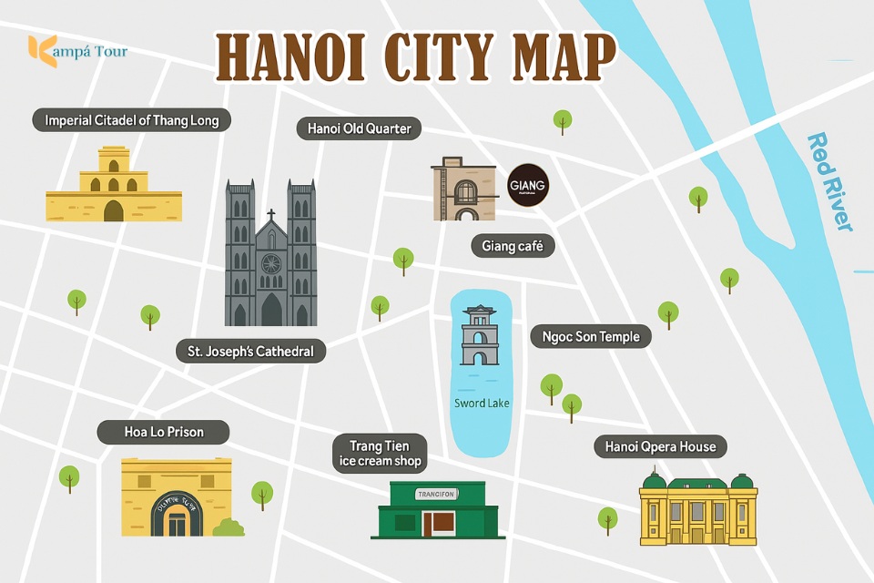
5.1 Hanoi Tourist Map
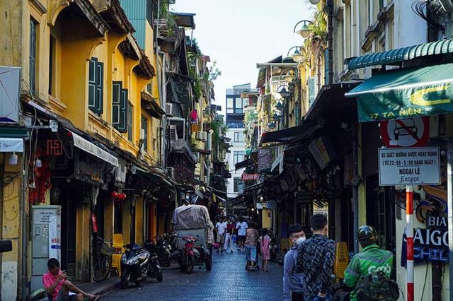
Hanoi, Vietnam's capital, is more than a thousand years old and rich in history. Its Old Quarter, with narrow alleyways and colonial houses, goes back to the 14th century and provides a true sense of the past. But Hanoi is more than simply old; it's dynamic, with modern cafes, delicious food, and thriving art scenes.
If you're planning to visit, try to stay at least two full days to really explore the city.
>>>> For a better view, click the [ ] icon to expand the map.
5.2 Ho Chi Minh City Tourist Map
Ho Chi Minh city (Saigon) is Vietnam's largest and most lively metropolis, combining legacy with modernity. The streets are alive with motorcycles, cafes, and a distinct local vibe.
French-style buildings, bustling markets, trendy bars, and skyscrapers all coexist in the same area. The city moves rapidly, yet there's always something worth stopping for - good food, a rich history, and unique experiences.
Bui Vien walking street
Here are some must-see places to make your stay in Saigon truly memorable:
Cu Chi Tunnels – Explore underground war-era passageways
6. Popular Vietnam Travel Routes & 14-Day Itinerary
6.1 Most popular routes in Vietnam
North Vietnam route: Hanoi → Sapa or Ha Giang → Ha Long Bay → Ninh Binh/Pu Luong
Central Vietnam route: Hue → Da Nang → Hoi An
South Vietnam route: Ho Chi Minh City → Mekong Delta → Phu Quoc or Con Dao
Our travelers staying at a homestay we helped develop in Pu Luong, Thanh Hoa.
In my opinion, if you only have about one week in Vietnam, it is best to stay in Northern Vietnam. The region offers some of the country’s most impressive highlights within a relatively short distance, including Hanoi’s Old Quarter, the mountain scenery of Sapa or Ha Giang or Cao Bang, the limestone islands of Ha Long Bay, and the countryside of Ninh Binh/Pu Luong.
Discover our best-selling Vietnam tours:
Thẻ tour 4821, 4820, 4819
6.2 Our suggested 14-day itinerary
Explore the best of Vietnam from north to south with this 10-day itinerary, guided by our detailed Vietnam tourist map for a seamless exploration!
Day 1: Arrive in Hanoi, explore the Old Quarter & colonial landmarks.
Day 2: Hanoi city tour, cultural sites, night train to Lao Cai.
Day 3: Lao Cai → Bac Ha, village hike, homestay.
Day 4: Bac Ha → Sapa, market visit, village trek.
Day 5: Sapa → Hanoi, explore Muong Hoa Valley.
Day 6: Hanoi → Ninh Binh, visit Mount Mua & Tam Coc.
Day 7: Hanoi → Halong Bay, cruise & cave exploration.
Day 8: Halong Bay → Hanoi, fly to Hue, visit Vung Vieng.
Day 9: Explore Hue’s Imperial City, pagodas & markets.
Day 10: Drive to Hoi An via Hai Van Pass, scenic stops.
Day 11: Full day in Hoi An, ancient streets & beaches.
Day 12: Fly to Ho Chi Minh City, visit historic sites.
Day 13: Mekong Delta – Ben Tre & Vinh Long.
Day 14: Cai Rang Floating Market, return to HCMC, depart.
Or make your trip completely stress-free by requesting a custom itinerary through our contact us page for a fully covered adventure!
Yes, Vietnam is very welcoming to all tourists and expats. Many American veterans return to visit old battlefields and witness the country's transformation over the years. Vietnam offers numerous beautiful tourist attractions, World Heritage sites, and stunning beaches, making it a popular destination for travelers.
2. Where is the best place to go in Vietnam for the first time?
For a first-time visit to Vietnam, either Hanoi or Ho Chi Minh City (Saigon) is ideal. Both cities offer rich history and culture unique to Vietnam. While Hanoi showcases the country’s ancient traditions, Ho Chi Minh City (Saigon) provides a dynamic, modern experience that's particularly easy for Western visitors to navigate and adjust to.
3. Do you need a tour guide for Vietnam?
It depends on your travel style. While private tours offer convenience, exclusivity, and access to incredible destinations like a bike ride through Ninh Binh, Vietnam can also be explored independently with proper planning, research, and an open mind. However, if you're concerned about scammers or want a stress-free experience on your first visit, booking a tour is a better choice.
4. Which is the best month to visit Vietnam?
The best time to visit Vietnam is from October to November or mid-March to May. These periods offer pleasant weather across regions, with minimal rain and ideal conditions for exploring the country’s diverse landscapes and attractions. For more information, please read: Best Time to Visit Vietnam & Why Vietnam’s Rainy Season Is Full of Surprises
5. Is Vietnam a safe country?
Vietnam is considered one of the safest countries in Asia for tourists. According to Gallup's Global Law and Order Report, Vietnam scored 92 out of 100, the highest in the region. Petty theft can occur in busy tourist areas, but violent crime is rare. Locals are generally welcoming and helpful to foreign visitors.
Conclusion
A Vietnam tourist map shows the country’s main regions, cities, and travel routes from north to south. It helps travelers plan itineraries, estimate distances, and discover key destinations in one visual overview. However, even the most detailed Vietnam tourist map can't fully capture the beauty and uniqueness of each region. So why not explore it for yourself? With its stunning natural beauty and many travel experiences to enjoy, Vietnam welcomes you!
>>> See more about things to do in Vietnam by month:
Hi! I’ll be traveling to Vietnam in January with my adult son, visiting Hanoi and Da Nang, and I have a few questions.
First, what local review platforms do people in Vietnam typically use? I know recommendations can vary by country.
We’re also hoping to hire a driver for a half day in each city. Are there reliable ways or platforms to find a trustworthy driver? I’ve seen some advice about being cautious with rides outside of Grab, but I’d also be happy to support drivers more directly if it’s safe.
Both cities have many markets, and we’d love to visit ones that are more local and less tourist-focused. How can we find good information about these?
Finally, are there any cultural customs or etiquette tips that tourists often overlook but should be aware of? We understand we’re visitors, but we’d like to be as respectful as possible.
Thanks in advance!
0Reply
T
Trang Nguyen from Kampá Tour30 Jan 2026
Hello Julia, thanks for the questions! I’m happy to share a bit of local perspective.
Local review platforms:
In Vietnam, most people rely heavily on Google Reviews and Facebook. Facebook is especially popular as locals often check comments, photos, and recommendations in Facebook groups or on business pages. TripAdvisor is used too, but it’s more common among international travelers than locals.
Hiring a driver:
For safety and reliability, ride-hailing apps like Grab are still the easiest and most trusted option, especially for short trips. If you’d like a private driver for half a day, a good approach is to book through a reputable travel agency or tour company, as they usually vet their drivers and vehicles carefully. This gives you a more personal experience while still ensuring service quality.
To help with your planning, we’ve also put together a few detailed articles that many travelers find useful. These are resources we’ve created ourselves with practical, local insight, and hopefully they can help:
You might find our guide to Dong Xuan Markethelpful if you’re interested in seeing a market that’s very much part of daily life in Hanoi.
This article on Ben Thanh Market gives broader context on how traditional markets work in Vietnam, which can still be useful even if you’re not visiting Ho Chi Minh City.
For cultural awareness, this guide on things not to do in Vietnam covers common etiquette mistakes visitors often overlook, along with explanations of local customs.
I hope these provide clear, useful context and make your trip planning a little easier.
0Reply
W
Wayna Leila12 Jan 2026
My husband and I are planning a trip to Vietnam in April or May, but we’re feeling a bit overwhelmed choosing where to go. We usually prefer natural scenery like beaches, countryside, and mountains over big cities. For a 4–5 day stay, which destinations would you recommend for a more local, nature-focused experience? Thanks in advance!
0Reply
Kampá Tour14 Jan 2026
You could keep it simple by choosing one of two routes for your 4–5 day trip.
The first option is Hanoi – Mai Chau – Pu Luong, which is ideal for mountains, rice terraces, and a very local countryside feel. It’s scenic, peaceful, and not overly crowded.
The second option is Central Vietnam: Hue – Hoi An – Da Nang, with a focus on the Lang Co area. This route offers a nice mix of beaches, lagoons, countryside, and culture. It’s still beautiful and relaxed, without feeling too busy or touristy.
Both routes are well-suited for a 4–5 day stay and work nicely if you’re looking for nature, local scenery, and a slower pace.
For reference, you can have a look at this sample northern itinerary: North Vietnam 5 Days Itinerary, which gives a good idea of how the route works in practice.
Hope this helps!
0Reply
J
Josh12 Jan 2026
I’ll be visiting Vietnam around mid-November. I’ve booked my flights to arrive in Hanoi and depart from Ho Chi Minh City. I’m planning to visit three places over 7 days: Hanoi, Da Nang, and Ho Chi Minh City. At the moment, I’m thinking of spending 2–3 days in Hanoi, 2–3 days in Da Nang, and 1–2 days in Ho Chi Minh City. I’d appreciate any advice on how many days to allocate to each place and what highlights I should see in each destination. Thank you.
0Reply
K
Kampá Tour16 Jan 2026
With 7 days, I’d suggest spending about 3 days in Hanoi, 2–3 days in Da Nang, and 2 days in Ho Chi Minh City. Hanoi is perfect for culture, history, and food, with highlights like the Old Quarter, Hoan Kiem Lake, the Temple of Literature, and the Ho Chi Minh area. If you have one extra day there, a short trip to Ninh Binh or Ha Long Bay is well worth it.
Da Nang is more relaxed and gives you easy access to beaches, scenery, and nearby heritage sites. You can visit Marble Mountains, My Khe Beach, and the Dragon Bridge, and definitely take a day trip to Hoi An for its old town, lanterns, and riverside atmosphere.
In Ho Chi Minh City, two days is enough to see the main sights such as the War Remnants Museum, Notre Dame Cathedral, the Central Post Office, and Ben Thanh Market, with the option of adding Cu Chi Tunnels or a short Mekong Delta excursion if you want something beyond the city.
Planning your trip?
Save time and get expert advice for FREE!
✅ 15 years of local experience
✅ Save up to 40 hours of planning
✅ Travel stress-free from start to finish
Book your free consultation today!


 Our team
 Our team
 Our team
 Our team

.jpg)
.jpg)
.jpg)


.jpg)

.jpg)
.jpg)

![[col-img15] vietnam tourist map](/pic/news/images/14c112a8-5302-439b-8963-08d906b81996.png)


Hello Julia, thanks for the questions! I’m happy to share a bit of local perspective.
Local review platforms:
In Vietnam, most people rely heavily on Google Reviews and Facebook. Facebook is especially popular as locals often check comments, photos, and recommendations in Facebook groups or on business pages. TripAdvisor is used too, but it’s more common among international travelers than locals.
Hiring a driver:
For safety and reliability, ride-hailing apps like Grab are still the easiest and most trusted option, especially for short trips. If you’d like a private driver for half a day, a good approach is to book through a reputable travel agency or tour company, as they usually vet their drivers and vehicles carefully. This gives you a more personal experience while still ensuring service quality.
To help with your planning, we’ve also put together a few detailed articles that many travelers find useful. These are resources we’ve created ourselves with practical, local insight, and hopefully they can help:
You might find our guide to Dong Xuan Market helpful if you’re interested in seeing a market that’s very much part of daily life in Hanoi.
This article on Ben Thanh Market gives broader context on how traditional markets work in Vietnam, which can still be useful even if you’re not visiting Ho Chi Minh City.
For cultural awareness, this guide on things not to do in Vietnam covers common etiquette mistakes visitors often overlook, along with explanations of local customs.
I hope these provide clear, useful context and make your trip planning a little easier.
You could keep it simple by choosing one of two routes for your 4–5 day trip.
The first option is Hanoi – Mai Chau – Pu Luong, which is ideal for mountains, rice terraces, and a very local countryside feel. It’s scenic, peaceful, and not overly crowded.
The second option is Central Vietnam: Hue – Hoi An – Da Nang, with a focus on the Lang Co area. This route offers a nice mix of beaches, lagoons, countryside, and culture. It’s still beautiful and relaxed, without feeling too busy or touristy.
Both routes are well-suited for a 4–5 day stay and work nicely if you’re looking for nature, local scenery, and a slower pace.
For reference, you can have a look at this sample northern itinerary: North Vietnam 5 Days Itinerary, which gives a good idea of how the route works in practice.
Hope this helps!
With 7 days, I’d suggest spending about 3 days in Hanoi, 2–3 days in Da Nang, and 2 days in Ho Chi Minh City. Hanoi is perfect for culture, history, and food, with highlights like the Old Quarter, Hoan Kiem Lake, the Temple of Literature, and the Ho Chi Minh area. If you have one extra day there, a short trip to Ninh Binh or Ha Long Bay is well worth it.
Da Nang is more relaxed and gives you easy access to beaches, scenery, and nearby heritage sites. You can visit Marble Mountains, My Khe Beach, and the Dragon Bridge, and definitely take a day trip to Hoi An for its old town, lanterns, and riverside atmosphere.
In Ho Chi Minh City, two days is enough to see the main sights such as the War Remnants Museum, Notre Dame Cathedral, the Central Post Office, and Ben Thanh Market, with the option of adding Cu Chi Tunnels or a short Mekong Delta excursion if you want something beyond the city.
For more information, you can also take a look at: Essence of Northern Vietnam in 7 Days itinerary.
Hope this helps!